Event: Desert Loop 125
Date / Time
Date: Saturday, March 1, 2025
Distance: 79 miles
Start Time: 6:00 AM
Checkin opens at 5:30 AM. There will be a mass start at 6 AM.
Start Location: Start Location is at McClintock Dr & Chandler Blvd in Chandler
(Get directions)
Time Limit: 8.2 hours
Sunrise: 7:01 AM
Sunset: 5:25 PM
Cost: $15
All riders must pre-register. (No day of event registration.)
RUSA sanctioned.
WAIVER NOTE :
You will be automatically directed to the online waiver after you submit your PayPal payment.
If you are not automatically directed to the online waiver after your pay, you may press the
"Return to Merchant" button to sign the waiver. The online waiver may also be
found at tinyurl.com/AZBrevetWaiver.
REGISTRATION NOTE : Once you are
registered for a ride, you will see your name in the
Registered Riders tab. It may take a day or so for it to
appear. Registered riders WILL be sent a "Last
Minute Notes" email the day after registration
closes, normally the Thursday before the ride. If you do not
receive it, please let me know. Also, check your spam folder
for the email.
RIDE VERIFICATION : All of these events
are sanctioned by Randonneurs USA (RUSA).
As such, all of them will be verified using approved RUSA
methods. Click HERE
to see the details of available options for AZ Radonneurs'
events.
Ride Description
Views of 4 Peaks while riding Bush Hwy
Desert Loop 125 Description
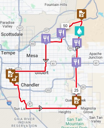
The Desert Loop 125k brevet route can be described as a sampler of some enjoyable riding areas in the Valley of the Sun. The route starts and finishes in Chandler and travels in a counter-clockwise direction.
The route travels coincident with longer events on the day so that riders will be able to ride with friends early on. Some highlights include Usery Pass, Lower Salt River Valley, "Kong" (a fun climb) and some bike trails thru Gilbert.
Services are located at regular intervals along the route.
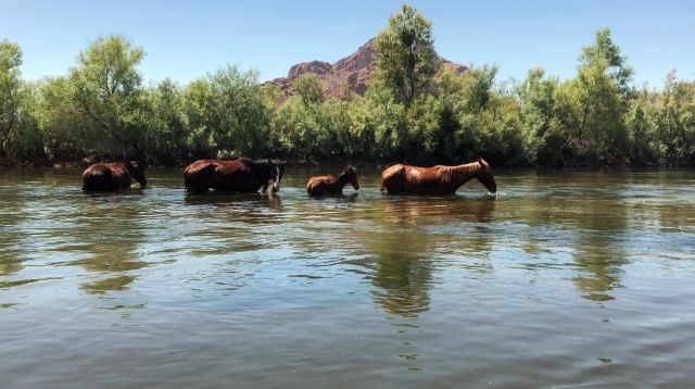
Terrain: The route follows the Lower Salt River Valley where wild horses are often spotted. This route only climbs 1400' and is a nice sampler of the area where locals often ride.
Start Location
Location: Start Location is at McClintock Dr & Chandler Blvd in Chandler
Address: 4040 W Chandler Blvd, Chandler, AZ 85226
> This address is a Circle K. See map linked below.
Directions: Click HERE for a Google map to the ride start location.
> Please park in the large lot north of the Circle K.
Route Information
View RWGPS online map here
Elevation profile:
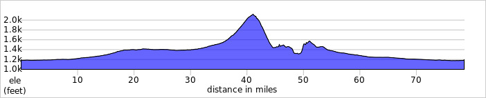
~1400 feet of climbing.
Cue sheets may be downloaded and printed by riders if they wish. Cue sheets will NOT be passed out at the start. Make sure you have a cue sheet as a backup in case your GPS fails.
(Excel format is not available.)
Create custom cuesheet
Rider Info
Lights, reflective vest, ankle bands are Required. Since riders will be starting coincident with the longer routes, the sun will not have risen yet at the start. This will be good practice for longer rides.
Services are spaced at regular intervals and are noted on the cue sheet and in the GPS file.
Please review this information prior to the ride so that you are familiar with what's available, and where it's located.
Registered Riders
1 Registered Riders.
| Rider Name | RUSA # | City | State/Prov |
|---|---|---|---|
| Mike Sturgill | 1847 | Phoenix | AZ |
Register
Click to Register >