Event: Desert Loop 300
Date / Time
Date: Saturday, November 8, 2025
Distance: 194 miles
Start Time: 6:00 AM
Checkin opens at 5:30 AM. There will be a mass start at 6 AM.
Start Location: Start Location is at McClintock Dr & Chandler Blvd in Chandler
(Get directions)
Time Limit: 20 hours
Sunrise: 7:01 AM
Sunset: 5:25 PM
Cost: $10
All riders must pre-register. (No day of event registration.)
ACP sanctioned.
WAIVER NOTE :
You will be automatically directed to the online waiver after you submit your PayPal payment.
If you are not automatically directed to the online waiver after your pay, you may press the
"Return to Merchant" button to sign the waiver. The online waiver may also be
found at tinyurl.com/AZBrevetWaiver.
REGISTRATION NOTE : Once you are
registered for a ride, you will see your name in the
Registered Riders tab. It may take a day or so for it to
appear. Registered riders WILL be sent a "Last
Minute Notes" email the day after registration
closes, normally the Thursday before the ride. If you do not
receive it, please let me know. Also, check your spam folder
for the email.
RIDE VERIFICATION : All of these events
are sanctioned by Randonneurs USA (RUSA).
As such, all of them will be verified using approved RUSA
methods. Click HERE
to see the details of available options for AZ Radonneurs'
events.
Ride Description
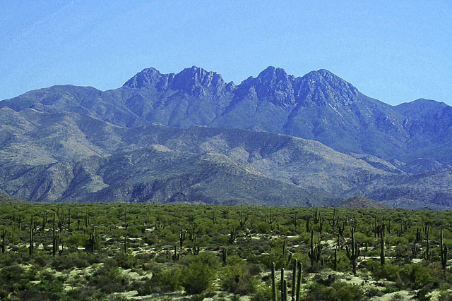
Views of 4 Peaks while riding Bush Hwy
Desert Loop 300 Description
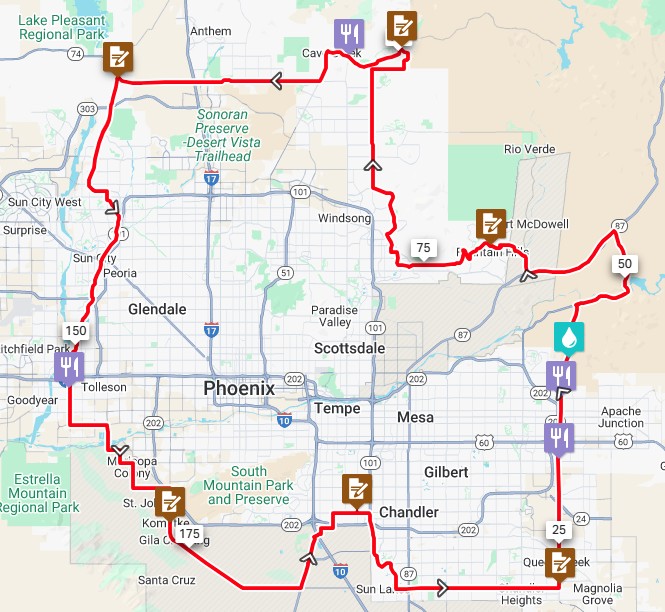
The Desert Loop 300k brevet route can be described as City meets Desert meets Farm meets Reservation in a repeating cycle. The route starts and finishes in Chandler and travels in a counter-clockwise direction.
The route travels along most of the length of the Valley of the Sun. This is on roads that generally skirt the outer reaches of the cities of the Valley, which together comprise the fifth largest metropolitan area in the United States. The roads were chosen to minimize traffic and stop lights, and many are formerly key roads that have been superseded by Interstate and highways, leaving them for cyclists to enjoy.
Services are located at regular intervals along the route. Towns and cities visited: Chandler, Queen Creek, Mesa, Fountain Hills, Scottsdale, Carefree, Cave Creek, Peoria, Estrella, Avondale, Laveen and possibly Phoenix somewhere in there!
Terrain: The route follows the Salt and Agua Fria River Valleys as it winds between several mountain ranges. While this route is relatively flat by Arizona brevet standards, with 5600 feet of total climbing, it differs from flat routes in other parts of the country in that it offers continually changing views of mountains in all directions along the entire course.
Start Location
Location: Start Location is at McClintock Dr & Chandler Blvd in Chandler
Address: 4040 W Chandler Blvd, Chandler, AZ 85226
> This address is a Circle K. See map linked below.
Directions: Click HERE for a Google map to the ride start location.
> Please park in the large lot north of the Circle K.
Route Information
View RWGPS online map here
Elevation profile:
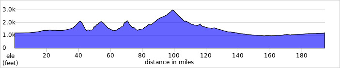
~5600 feet of climbing.
Cue sheets may be downloaded and printed by riders if they wish. Cue sheets will NOT be passed out at the start. Make sure you have a cue sheet as a backup in case your GPS fails.
(Excel format is not available.)
Create custom cuesheet
Rider Info
Lights, reflective vest, ankle bands: Required. There will be a light inspection at check-in to verify front and rear lights are working and are sufficient for night riding.
Services are spaced at regular intervals and are noted on the cue sheet and in the GPS file.
Please review this information prior to the ride so that you are familiar with what's available, and where it's located.
Registered Riders
3 Registered Riders.
| Rider Name | RUSA # | City | State/Prov |
|---|---|---|---|
| Steve Atkins | 3359 | Tempe | AZ |
| Brian McGuire | 7406 | Phoenix | AZ |
| Mike Sturgill | 1847 | Phoenix | AZ |
Register
Click to Register >