Event: White Mountains 8k600
Date / Time
Date: Saturday, October 4, 2025
Distance: 375 miles
Start Time: 6:00 AM
There will be a mass start at 6 AM and announcements and time for questions at 5:55.
Start Location: Best Western Plus, Stafford
(Get directions)
Time Limit: 40 hours
Sunrise: 5:17 AM
Sunset: 7:30 PM
Cost: $25
All riders must pre register. There is no day-of-event registration.
ACP sanctioned.
WAIVER NOTE :
You will be automatically directed to the online waiver after you submit your PayPal payment.
If you are not automatically directed to the online waiver after your pay, you may press the
"Return to Merchant" button to sign the waiver. The online waiver may also be
found at tinyurl.com/AZBrevetWaiver.
REGISTRATION NOTE : Once you are
registered for a ride, you will see your name in the
Registered Riders tab. It may take a day or so for it to
appear. Registered riders WILL be sent a "Last
Minute Notes" email the day after registration
closes, normally the Thursday before the ride. If you do not
receive it, please let me know. Also, check your spam folder
for the email.
RIDE VERIFICATION : All of these events
are sanctioned by Randonneurs USA (RUSA).
As such, all of them will be verified using approved RUSA
methods. Click HERE
to see the details of available options for AZ Radonneurs'
events.
Ride Description
The White Mountains
of AZ are a stark contrast to what most riders think about when they think
about Arizona. This is a challenging route, as are all of the 8k600 routes. It
officially has 8000 meters of climbing over 600km. The time allowed for
completion is also only 40 hours. Efficiency will be key to making the time
cutoff.
With that said, the White Mountains are a gem to ride. The
population density is quite low and the elevations reach 9400’. There are
resources available to refuel and lodging options available based upon one’s
own preferences for how to split the route.
The ride starts in the mining town of Safford
in the high-ish desert. Leaving early to beat the potential heat will be a
must. Once you start rising to the higher elevations, the temperatures should
be pleasant. Most of the route will remain at high elevations. Nights can still
be cold at these elevations and riders should plan for that.
You will enter New Mexico at mile 53 while in the Apache
National Forest. The climbing to get up to the pines is mostly gentle, but
long. The roads are graded nicely and not too steep. On your way to the highest
elevations, you’ll make a detour to Reserve, NM. You will be far enough into
the ride to be ready for some food. This might be a good place to replenish.
There is also a fantastic restaurant just before you make the turn to Reserve
if you feel like treating yourself.
Continuing after Reserve is a 15 mile climb up to 8000’. It’s
gradual and mostly traffic free. Following a fun descent, you’ll start your
next sustained climb to Alpine,
AZ, named after the European Alps. Once in Alpine, you’ll make an 80-mile
loop back to Alpine. This loop will range in elevation from about 7000’ to 9400’.
The air is thin and the views are spectacular! There are multiple lodging
options on this loop and gives you options for an overnight(?) respite.
After Alpine on the return, riders will “descend” the Coronado
Trail. This descent loses 4000’ in elevation, but still manages to climb over
9000’ in those 100 miles. Hannagan Meadow
(9100’) is on your route and is not much more than a wide spot in the road, but
there is an awesome lodge and restaurant there. You will definitely want to
resupply here. This will be your last water availability until you get to
Morenci. Descending the Coronado Trail will be an experience you won’t soon
forget. Some of the tightest hairpin turns I’ve ever experienced are on this
road.
After a couple major climbs on the descent, you’ll finally
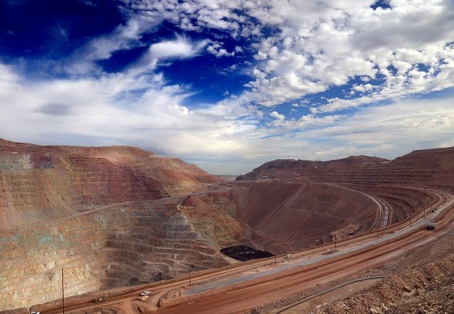
reach the Morenci Mine.
It is one of the largest copper mines in the world. This mine started in 1871
and has continuously grown as an open-pit mine to this day. It’s mind-boggling
to look into the mine and see how enormous it is! The Coronado Trail (US-191) has been re-routed and rebuilt countless times around the mine to account for its remarkable growth.
After your refuel stop in Morenci, there are still a couple
climbs to negotiate. With about 25 miles to go, you’ll summit the last climb
and descend back to the finish. Phew!

Start Location
Location: Best Western Plus, Stafford
Address: Best Western Plus
450 Entertainment Ave, Safford, AZ 85546
Phone: 928.348.9400
Google map:Click HERE
Directions: Just off Hwy 70 E in Safford, AZ
Route Information
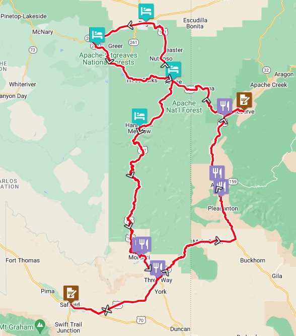
View RWGPS online map here
High elevation climbing will be on the agenda!

Elevation profile:
This is an ACP 8k600 route with 8000m (28,000') of climbing over a 600 km distance with 40 hour time cutoff. White Mountains sampler the hard way!

Cue sheets may be downloaded and printed by riders if they wish. Cue sheets will NOT be passed out at the start. Make sure you have a cue sheet as a backup in case your GPS fails.
(Excel format is not available.)
Create custom cuesheet
Rider Info
Lights: Required. There will be a light inspection at check-in to verify front and rear lights are working and are sufficient for night riding. Also required are reflective vest or sash and ankle reflectors.
This route is very remote in a couple areas and riders must plan accordingly for:
1) Food & water
2) Clothing - due to elevation differences
3) Overnight lodging
The RWGPS and cue sheet list the areas where resources are reliably available. There will be few other places to find food/water/lodging.
Accommodations - Accommodations are the rider's responsibility so that you may choose your price and overnight options. The route lists areas where overnight accommodations are available on-route.
Registered Riders
1 Registered Riders.
| Rider Name | RUSA # | City | State/Prov |
|---|---|---|---|
| Mike Sturgill | 1847 | Phoenix | AZ |
